
We were in Lago di Monate, and wanted to get to Lago di Braies/Pragser Wildsee. When we Google Mapped the route, it gave us two options: we could drive through Italy, take the toll roads, and arrive in Braies today, OR, we could take the slow route, drive north to Chur, Switzerland, through Lichtenstein, over to Innsbruck, Austria, and then down to Braies.
There we lay, in the sun, on a pedalo, in the middle of the lake, weighing our options. On one hand, we could wake up in Braies tomorrow! On the other, we could visit our friend, Luca, in Chur, see a country we’ve never seen, go to an original version showing of Solo: a Star Wars story (which, is near impossible to find in Italy) in Innsbruck, Austria, and then drive down through the Dolomites, to Braies. So, on that pedalo, in the sun, in the middle of that lake, we decided to drive to Switzerland.

We drove out of Italy with one last stop to the grocery store. We need beer, meat, cheese, snacks— all the things you can’t get in Switzerland for a reasonable, cheapskate price. Our van was packed with Italy-cheap necessities, and we were on the road. As soon as we drove across the border, the highway was pristine, the cars drove the speed limit, and we were surrounded by beautiful mountains and incredible waterfalls. Welcome to Switzerland.
First country: Switzerland
On our second day in Chur, Switzerland, we woke up early and drove to the Pradaschier Toboggan run! On this day, between 9am and 11am, the tickets were two for one. Michael and I were a little bummed to find out they meant two rides for the price of one, not two adults for the price of one, BUT we decided to go anyway. Luckily, nobody else decided to come to the rollercoaster this day, and so, we were the only three people in the place! We took a chairlift to the top of the hill, which boasted stunning views of the whole valley, and found the top of the toboggan run. This is a 3 kilometre rollercoaster-type ride, that snakes down the hill, and ends back at the bottom of the valley. The toboggan itself is basically a chair that’s connected to the track, and the rider is strapped in with only a seatbelt and controls only the brakes.
One at a time, the rollercoaster operator showed us how to use the brakes, fastened our seatbelts properly, and made sure the coast was clear — of course it was clear, we were the only people there. Luca went first, then Michael, and then it was my turn! The man strapped me in, demonstrated again how the brake lever works, and then I was off! Ahh! The first drop out of the gate was quick! The toboggan flew down the track! I came to the first corner too fast, so pulled on the brakes. As I rounded the corner, I let out a small giggle. I let the brakes go, and my speed picked up again. My hair whipped out behind me, the wind muted my squeals and giggles — I was having the best time! I whizzed above wildflowers, hurtled through alpine meadows, and zipped past the grazing cows with their clanging bells. The smile plastered on my face was unshakeable. When I finally arrived at the bottom, I could see Michael with the camera ready for a picture, and Luca, already half done a cigarette. Was I gone that long? But it felt so fast! It was such a rush! And the best part? We get to go again!
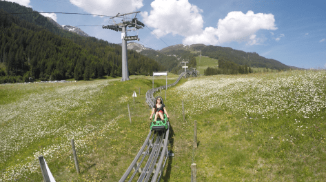
Michael smiled and asked how it was, “AMAZING!” I replied! We walked back to the chairlift and the operator said something in German. Luca replied, and they both laughed. Luca turned to me and explained that the operator was making fun of how slow I went down the hill, “where was she?!” he had joked, “that’s the slowest run I’ve ever seen!” I smiled. I knew I had gone slow, but it felt fast enough for me, and I had so enjoyed myself! So, we sat in the chairlift again, and it whisked us up to the top of the hill. Michael asked if I wanted to go in his toboggan this time, but he would be in charge of the brakes. I knew that meant we would go fast, so I hesitated, but agreed in the end.

Michael climbed in first, and strapped himself in. I sat in between his legs, and strapped my own seatbelt, making sure it was as tight as possible. The rollercoaster operator told me to keep hold of the handle — let’s call it the ‘holy shit handle’ — the whole time. My heart started pounding. “You ready, babe?” Michael asked from behind me. I nodded, but wasn’t actually ready enough to use my words. The gate released and we were off. Immediately, going three times faster than I went on my own. We flew down the hill, flying over the bumps in the track, coming into the corners hot, and exploding out of them. The whole way down I half laughed, half screamed, because I felt half happy, and half utterly terrified. When we arrived at the bottom, my legs were jelly! And the best part? We don’t have to go again!
Second country: Lichtenstein
We hit the road. Google Maps took us north, out of Chur, along the valley, and towards Lichtenstein. One thing I’ve learned about Europe from driving through it, is how the countries seem to be divided by very obvious borders: huge rivers, big hills, or giant mountain ranges. We drove out of the mountain valley, and as we drove out from the shadow of the mammoth peaks that are the Swiss mountains, we saw a “Welcome to Lichtenstein” sign. Within ten minutes of being in Lichtenstein, we saw three archery ranges. Within another ten minutes, we drove past another sign, “Welcome to Austria” and we were back in the mountains, feeling lucky we hadn’t been shot with an arrow.
Third country: Austria
We made it for the original version showing of Solo: A Star Wars Story! It played only one time in the week, in one theatre in Innsbruck — on Tuesdays at 5pm. We were two of the six people in the theatre, and arguably, the most excited. Yay! The next day, we thought we would leave Austria, and finally make our way to Braies. But, something came up…
Last year, when we visited Austria the first time, we did a three day hike through the alps, that finished in a town called Umhausen (you can read the story about that hike here!). The last stretch of the hike was down an enormous staircase next to the biggest waterfall in Austria, Stuibbenfalls. We had seen some folks doing a vía ferrata up the side of the falls, and we decided it would be the coolest activity to do. We realized that Innsbruck is only 45 minutes away from Umhausen, and so, decided to drive there to do the vía ferrata!
Michael found a campground that would rent us the equipment, so we head there. We collected our harnesses, carabiners, and helmets, and walked along the trail to the beginning of the route. The vía ferrata began with a river crossing. One at a time, we clipped to the cable, and slowly made our way across the water. The cables were wobbly, making it hard to clip and unclip our carabiners. I had to ignore the thunderous rumbles of the rushing water below me in order to stay calm!

The route was quite easy after the river crossing. There were some parts of the path that felt more like a hike than a vía ferrata, and we found ourselves doing a lot of it without clipping onto the cables at all. Until the end. We reached the wall next to the waterfall. Stuibbenfalls is 159m (about 521ft) tall. The water erupts from the top of the cliff, bombs down the face, and slaps the rocks along the way. It roared as it passed us. I couldn’t even hear myself think, let alone hear the words coming out of Michael’s mouth. The final step of the vía ferrata was to cross the top of the waterfall. I’ll write that again so you have a second chance to make sure you read it correctly. To end the route, we have to cross the top of the waterfall. Two horizontal cables ran across the precipice, more cables hung between them, and acted like rungs of a ladder turned on its side. A third horizontal cable stretched a little ways above — that was the one we would clip our harnesses to. Michael went first. He clipped onto the top cable, and slowly shuffled across the bottom two. He was a champ! When he reached the halfway point, he posed for a picture, as if it was the most normal place to be, balancing on a lone cable, stretched across a monstrous waterfall, 159m above the ground. It was my turn. I clipped my harness, and I too, slowly shuffled out onto the cable. Immediately, I felt so powerful, like I was on top of the world. I laughed and screamed down the cliff, into the valley below. The water behind me splashed my legs and ankles. When I made it to the other side, I was greeted with a huge kiss from Michael. We did it!

The next morning, I woke up when cow bells began clanging in the distance. I stirred in bed, rolled over and opened my eyes. The clanging bells became louder. And louder. I opened the blackout blinds on the back window, and discovered three cow bums a metre away from the van. Holy shit! Then, a large whump on the side of the van and Michael jolted awake. A cow had banged right into the side of us! I shot out of bed and opened the curtains to the cab, cows there. I opened the blackout blinds over the kitchen counter, cows there. Cows to the sides, cows to the front, cows to the back…we were surrounded! I wonder if the cows think Vinnie is a cow too? I guess all the rust on him could look a bit like cow spots. It was the perfect Austrian alarm clock, and once the cows were finished humping the side of the van, or whatever it was they were doing, we left!
Fourth country: Italy (again)
We finally found Lago di Braies, also known as Pragser Wildsee, aka The Pearl of the Dolomites. The lake is surrounded on all sides by magnificent mountains, and the colour of the water is a deep and beautiful turquoise green.

The place is a bit touristy, with a big chalet hotel, lots of parking space for tour busses, and the almost laughably photogenic rowboats for rent, at a totally laughable price. No bother for us tho, the weather wasn’t all that nice, so we found ourselves walking around the lake alone. We sat at one of the benches, and looked out over the water, up at the towering mountains around us. Phew, life is good. (Check out some videos I took of the lake with my DJI Spark below!).

Our short Google Map route turned into a five day, super exciting detour, that gave us memories we will never forget. Perhaps we shouldn’t always look for the fastest way there. Perhaps sometimes, we should opt for the slow route, the route that may take longer, and could possibly take us places we might not otherwise go. Maybe that’s the lesson here.


